SA Release 2025.1
 At Hexagon’s Manufacturing Intelligence division, we are dedicated to the continuous development of our core portable metrology software package, SpatialAnalyzer® (SA). We pay close attention to our users' feedback and regularly incorporate user suggestions into new releases. In fact, you'll find that we never stop improving and enhancing SA.
Read below for the latest updates, enhancements, and fixes in SA Release 2025.1. Click here for the download page.
SpatialAnalyzer Version 2025.1
Click here to view this in pdf format.
CAD Import
Updated Import Formats:
- AutoCAD 2024, Autodesk Inventor 2025, Autodesk Navisworks 2025, CATIA V5_6R2024,
- Creo 11.0, DGN 8, IFC2 up to 2.3.0.1, IFC4 up to 4.0.2.1, NX - Unigraphics NX2412, Parasolid 37.0
- Revit 2025, Rhino3D 8, Solid Edge 2025, Solidworks 2025, STEP AP242 E1/2(beta)/3(beta)
Expanded Direct CAD Import to Include Merge Objects:
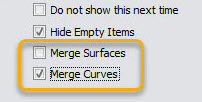
Some CAD formats can include thousands of items within them. Importing these files and then sorting and condensing them within the SA tree can take pose a challenge. There are now an intelligent options to merge surfaces and curves (b-splines) as part of the selective CAD Import process. This option condenses tree items based on the CAD's inherent structure and can greatly reduce the number separate pieces built within the SA tree on import.
Point Cloud Operations
Auto-Detect Sphere Centers Offer Cloud Construction
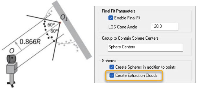
An additional final fit can be performed to remove outliers and refine the solution based on the associated instrument station. Enabling the option to perform a “Final Fit” will use the ASTM E3125-17 fitting algorithms. The point cloud data is filtered so that only a central cone opening angle of 120° is used to compute the sphere and its center point. There is now an option to save these filtered clouds as part of the sphere point detection process:
Cross Section Measurement
Added New Multi-Geometry Building Tool
A new tool has been added to easily define and construct a series of items at tone time. This tool works great for creation of geometries for cross section cuts as an example. Several options are included:
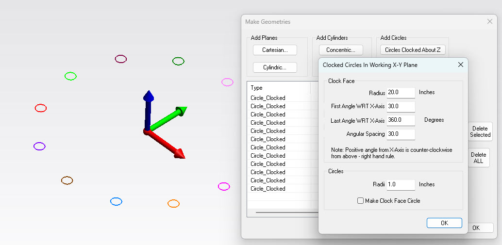
- Planes at set distances along selected working frame axes
- Planes rotated at set intervals about working frame z-axis
- Concentric cylinders centered on working frame z-axis
This tool also offers a method to build clocked circles about working frame z-axis. This can be very helpful in spool flange measurement.
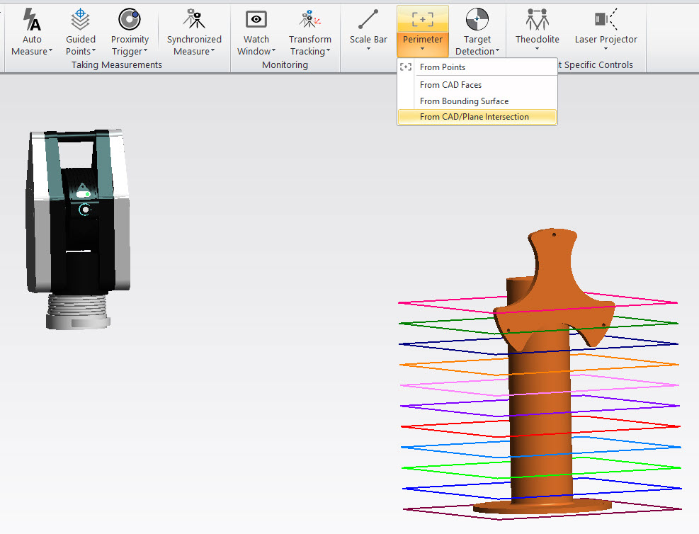
Perimeter Construction Options
Added a new construction option to create perimeters "From CAD / Plane Intersection". This uses a selected instruments perspective to build a set of open perimeters for cross section measurement.
Expanded Cross Section Clouds
Cross-section clouds can now be build directly through measurement. It is now possible to scan directly into a cross section cloud with devices like the Leica ATS600.
- The default mode for the ATS600 Line Scans is now "Linear" and a new method Separate Cloud Per Line is now available to facilitate this measurement method which will produce a scan stripe cloud as the measurement result for easy analysis.
- An additional construction method has been added to allow separate clouds in the tree to be combined into a cross section cloud.
2D Callout View
Added a 2D callout view lock mode. This mode allows you to pan the graphics but not rotate from the intended view orientation.

Click Here to see a YouTube demonstration.
Updates for Roller Alignment
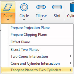
New Dynamic Tangent Plane
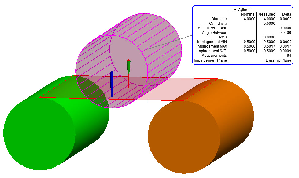
There is now an option to build a dynamic tangent planes based upon the selection of two nominally parallel reference cylinders. Selection is available for all 4 possible tangent variations (top, bottom and both angles).
Impingement Plane for Cylinders
The impingement plane concept was added to aid in roller alignment applications. The idea being that the reference roller should be set at a given depth relative to a tangent plane set by the two adjacent rollers. The 3 Impingement criteria are computed dynamically to return statistics on these values.
Click Here to see a YouTube demonstration.
Feature Inspection Updates
New Torus Geometry Relationship
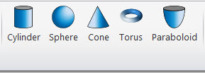
Toroid geometry is now included in SA's list of dynamic features. When measuring bearing races and other similar shapes this feature will greatly aid in measurement and reporting.
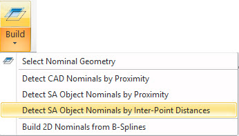
Detect SA Object Nominals by Inter-Point Distances
A more advanced option has been added to detect and add nominal items to measured GR-Features. This option allows point reducible features like circles, slots and spheres to find their nominal based on the spacial distribution in the job file, prior to alignment. This new function works great for applications such as initial part alignment after scanning. For example you can now import CAD and build nominal features from it, scan the part and directly extract desired alignment features from the cloud. This new tool can then be used to directly match up nominal and measured features in one go. This works great when performing a Nominal Geometry Relationship alignment for example.
Convert Measured Points to Guided
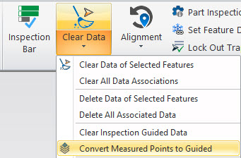
Guide points can be very helpful for inspection and they can also be used for auto measure operations. The Convert Measured Points to Guided option offers the ability to directly convert a measured set of features into a template that is pre-configured with guide points. The same operation is available on R-click Relationships branch menu. Added new menu option "Clear Inspection Guided Data" to remove guided points from the assigned relationships.
Click Here to see a YouTube demonstration.
Expanded Trapping Controls for GR-Features
A selection of helpful updates have been made to the Trapping Controls dialog and the options it offers.
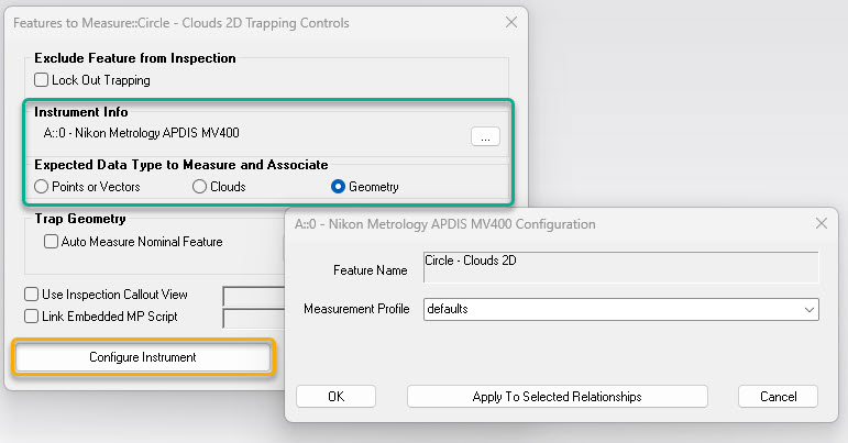
- The Trapping Controls dialog now dynamically adjusts to display only the relevant controls for the selection measurement operation. This includes adjustment for the Configure Instrument display:
- When Clouds are selected a directly link to the proximity filter options is provided.
- Added ability to apply Trapping Controls to the selected relationship of the same type. The new functionality is applicable to all relationships that have Trapping Controls option.
- The application opens a Target Watch Window for sequential trapping instead of the Closest Point watch window.
- Modified Inspection Callout View assignment in the Trapping Controls dialog on checking “Use Inspection Callout View” option. User can create new callout view or select existing one.
- Added Trapping Controls option to the following dialogs: Average Point Relationship Properties, Geometry Relationship Properties, Points to Objects Relationship Properties, Cloud to Objects Relationship Properties.
Expanded Multi-Feature Trapping
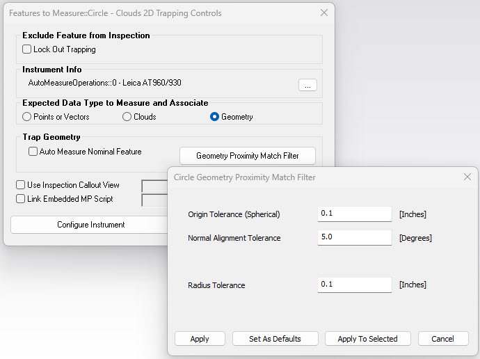
There is now an option to trap geometry using multi-feature trapping. The geometry acceptance tolerance settings have also been added to the trapping controls:
Expanded Measure Batch of Features
The Measure Batch of Features command now includes Sphere's and Cylinder geometry. The Trapping Controls dialog within each GR-Feature includes a Geometry selection control to aid in building a template for these measurements.
Click Here to see a YouTube demonstration.
Updated Alignments
Improved RPS Alignment
Point to Point relationship are now compensated using the surface normal directions saved with the target points. This can help to ensure the desired fit even when measurements do not directly match the nominal location on angled surfaces. This also works great with the Detect SA Object Nominals by Inter-Point Distances option.
GDT Inspection
Expanded Simultaneous Evaluations
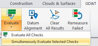
This version completes comprehensive support for simultaneous evaluations as a template default for support of the ASME standard. Annotations marked with specific text such as "SEPT REQT" in the text below field will be automatically excluded from the simultaneous default requirement set in the user Options. A selective simultaneous evaluation option is now also available which allows the default to remain off and only the selected checks be evaluated together. Doing so also creates a dynamic event in the tree that offers the ability to re-compute the prior selection of checks. The GDT Ribbon Menu has been updated to offer direct access to the GDT User Options, Simultaneously Evaluated Selected Checks, and an option to Clear All Results, which is helpful when using locked results.
Click Here to see a YouTube demonstration.
Improved Multi-Feature Point Associations
GR-Feature points associations are now used directly within a GDT Feature Check that references multiple inspection features. Feature checks that include references to a bunch of different items, such as a position check on a hole patter, have always used proximity to determine which points are associated with which features. This can cause problems if the alignment is significantly off. Building checks from GR-Features eliminates this problem.
Improved User Interface Controls
Added Reference Frame Selection for Transforms
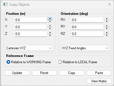
Rotate objects in 3D space with greater ease and precision through a selective reference frame. This version implemented a user selectable reference to either the current working frame or the objects own starting orientation, or its Local frame. This allows position changes to be applied with respect to either the Working frame or the starting position. Note that this option is only available where there is a single moveable object in the object move list.
Construction Operations
Cylinder Construction
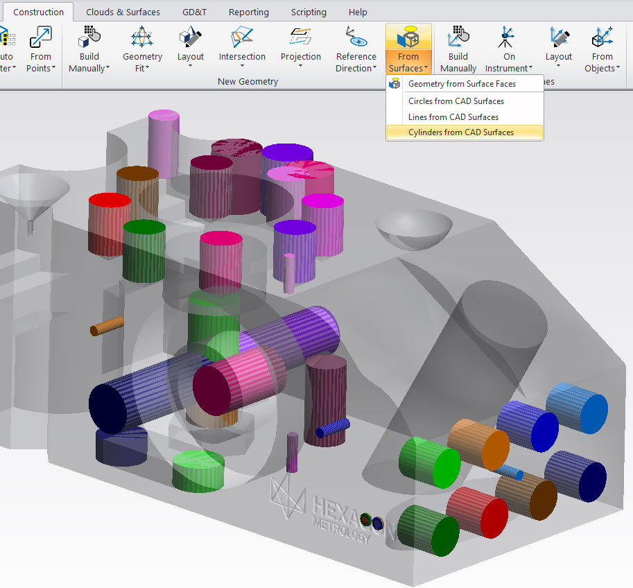
Added Construct Cylinders from CAD Surfaces to the list of extractions available within the From Surfaces options.
Instrument Operations
Vertical Alignment Status Display
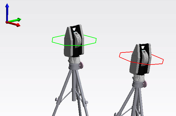
There is now a graphical indicator that can be enabled within SA to display the Vertical Alignment of an instrument in the job file. This status indicator is enabled automatically when you measure level within a job file and will account for level compensation such as Leica's OTG and API's Virtual Level. The reference frame and additional tolerance controls are available within the instrument's right-click menu.
Right-click Point at Surface Point
A new option has been added which allows you to right-click on a point on a CAD model and directly point the instruments beam at that location. This only works if you are first aligned to the part but can be quite helpful after that, when measuring particular features. It works just the same as right-clicking on an existing point and selecting Point At.
New Instruments Added
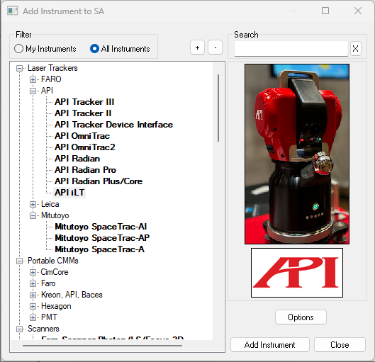
API iLT Laser Tracker
The latest API iLT Laser Tracker is now supported. This new tracker is significantly smaller than the other Radian laser trackers. This version includes API's latest SDK and support for the vprobe.
Additional Instrument Updates:
Leica ATS600
Now supports measuring into Cross Section clouds directly as part of a Line Scan measurement profile.
PCMM Arms
Add Keyboard Measure Button for Arm Interface. This allows measurements to be triggered from an arm without pressing any of the arm buttons manually.
Total Stations
Improved Video Performance and mouse Click-Driving operations.
Nikon APDIS Laser Radar
Added SDK update and tighter integration with the GR-Feature measure batch of features options. Improved auto measure of SA Geometry Relationships (Features) by MV430E/MV450E Gauging Engine (GE). This includes the addition of GR-Spheres and GR-Cylinders to the list of supported geometry types.
Hexagon Handheld 3D Scanner
Updated performance and synchronization with the HHScann measurement process.
LAP Laser Projectors
Added MP Op Check string command, "Zero Projector Transform".
MP/SDK Scripting Updates
New Diagnostic tools added:
Added MP profile diagnostics that will generate an output file: "Analyzer Data\MPStepTimeLog.csv". This can be used to identify what commands may be slowing down an application.
New MP Commands
- Get Instrument Group and Target. Returns the collection, group and target name currently set within the selected instrument.
- Get Instrument Measurement Mode / Profile. Returns the name of the current measurement profile or mode active for the selected instrument.
- Get Instrument Targeting. Returns the current target name set for the selected instrument.
- GMesh Fill Holes. Offers the ability to either automate mesh hole filling or prompt an operator to select holes to fill.
- Set Cone Properties. Allowed direct editing of the properties of an existing cone.
Updated Commands
- Auto Filter Clouds to Nominal Geometry 3D. Added "Use Filter Settings?" toggle to specify whether to use the proximity cloud auto filter settings.
- Direct CAD Access. This command has been updated to default to True for Surface Compatibility Mode.
- Construct Objects From Surface Faces - Runtime Select. This command has been updated to offer more geometry types and point exaction methods.
- Feature Inspection Auto Filter. Now only filter to explicitly added feature checks.
- Get Cone Properties. Added Cut Length from Apex.
- Get General Relationship Statistics. Renamed Max Deviation to Absolute Max Deviation.
- Get Points to Objects Relationship Statistics. Added new argument Avg Deviation.
- Mesh Volume. This command has been corrected to work with angled planes.
- Re-Compute Calculated Items. Added "Refresh Filtered Cloud Data?" argument.
Click here to view this in pdf format.
Interested in learning more about SA? We regularly update the SA User Manual (which is installed when you install SA) to reflect the most recent updates and changes to SA. Click here for the download page.